- Openlayers5부터 node.js로 npm으로 받아서 하는 es6방식으로 바뀌어서
필자는 Openlayer4를 사용하여 지도를 표출하는 방식으로 개발해보겠습니다.
index.html
<!DOCTYPE html>
<html>
  <head>
    <title>Accessible Map</title>
    <link rel="stylesheet" href="https://openlayers.org/en/v4.6.5/css/ol.css" type="text/css">
    <!-- The line below is only needed for old environments like Internet Explorer and Android 4.x -->
    <script src="https://cdn.polyfill.io/v2/polyfill.min.js?features=requestAnimationFrame,Element.prototype.classList,URL"></script>
    <script src="https://openlayers.org/en/v4.6.5/build/ol.js"></script>
    <style>
      a.skiplink {
        position: absolute;
        clip: rect(1px, 1px, 1px, 1px);
        padding: 0;
        border: 0;
        height: 1px;
        width: 1px;
        overflow: hidden;
      }
      a.skiplink:focus {
        clip: auto;
        height: auto;
        width: auto;
        background-color: #fff;
        padding: 0.3em;
      }
      #map:focus {
        outline: #4A74A8 solid 0.15em;
      }
    </style>
  </head>
  <body>
    <a class="skiplink" href="#map">Go to map</a>
    <div id="map" class="map" tabindex="0"></div>
    <button id="zoom-out">Zoom out</button>
    <button id="zoom-in">Zoom in</button>
    <script>

		var map = new ol.Map({
			layers: [
          		new ol.layer.Tile({
            		source: new ol.source.OSM()
				})
			],
        	target: 'map',
        	controls: ol.control.defaults({
          		attributionOptions: {
            		collapsible: false
				}
       		}),

        	view: new ol.View({
          		center: [126.977885, 37.5662378]
         	 	,zoom: 17
         	 	,projection : 'EPSG:4326'
       		 })
      	});

     	 //줌아웃
      	document.getElementById('zoom-out').onclick = function() {
        	var view = map.getView();
        	var zoom = view.getZoom();
        	view.setZoom(zoom - 1);
      	};

      	//줌인
      	document.getElementById('zoom-in').onclick = function() {
			var view = map.getView();
			var zoom = view.getZoom();
			view.setZoom(zoom + 1);
		};


    </script>
  </body>
</html>
view: new ol.View({
	center: [126.977885, 37.5662378]
	,zoom: 15
	,projection : 'EPSG:4326'
})
구글맵은 EPSG:3857
openlayers에서는 EPSG:4326을 사용하고 있으므로 EPSG:4326으로 변환
위에 경도, 위도 값은 구글맵에서 시청의 위도, 경도 값입니다.

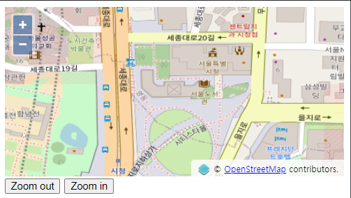
- 결과화면

서울특별 시청이 보이는것을 확인할수 있습니다.
Zoom out과 Zoom in을 클릭해보면 동작을 확인할수 있습니다.
'gis > Openlayers' 카테고리의 다른 글
| [Openlayers] 마우스로 도형 그리기 (0) | 2022.02.17 |
|---|---|
| [Openlayers] wms 적용하기 (0) | 2022.02.17 |
| [Openlayers] vworld wmts, map, pin, polygon, circle 객체 올리기 (0) | 2022.02.17 |

